# capture-coordinates
## Overview
{% hint style="info" %}
The `capture-coordinates` component was visually updated in version **4.82.0** of JourneyApps Runtime.
{% endhint %}
The `capture-coordinates` component allows users to capture their current location. The captured location will be displayed on a map with a marker.
{% tabs %}
{% tab title="Light Mode" %}

{% endtab %}
{% tab title="Dark Mode" %}

{% endtab %}
{% endtabs %}
### Basic Examples
#### Capture coordinates & markers
The following example shows how GPS location capturing can show a mix between `marker-query` and `marker` nodes.
In the example the captured location will be bound to the variable specified in the `capture-coordinates` `bind` attribute. Markers are simply locations that are being visually highlighted on a map. This is useful to, for example, show where the captured location is in relation to other points of interest.
```xml
```
#### "Foreground" Capturing
The following example shows how GPS location capturing can be performed in the "foreground" i.e. the user sees a map showing how their GPS location is captured.
```xml
```
#### "Background" Capturing
Using the `show-if` configuration option, it is also possible to capture a GPS location in the background (i.e. the map pictured in the screenshot above is not shown)
```xml
```
## Standard Attributes
### `bind`
**Required**
**Type:** `location`
**Default**: unset
The `capture-coordinates` component uses the GPS location of the device and sets this value on the `bind` variable/field. This value will update as accuracy increases of the device's GPS location. A marker will autogenerate at the bound location if no `` or `` is defined. See [show-markers](#show-markers) for more information on hiding markers.
{% hint style="info" %}
Must be a variable or field of type `location`. See the reference on [data model fields](https://docs.journeyapps.com/reference/build/data-model-configuration/model/field) for more details.
{% endhint %}
```xml
```
### `label`
{% content-ref url="../xml-fields/label" %}
[label](https://docs.journeyapps.com/reference/build/ui-components/xml-fields/label)
{% endcontent-ref %}
### `required`
{% content-ref url="../xml-fields/required" %}
[required](https://docs.journeyapps.com/reference/build/ui-components/xml-fields/required)
{% endcontent-ref %}
## Advanced Attributes
### `align-content`
{% content-ref url="../xml-fields/align-content" %}
[align-content](https://docs.journeyapps.com/reference/build/ui-components/xml-fields/align-content)
{% endcontent-ref %}
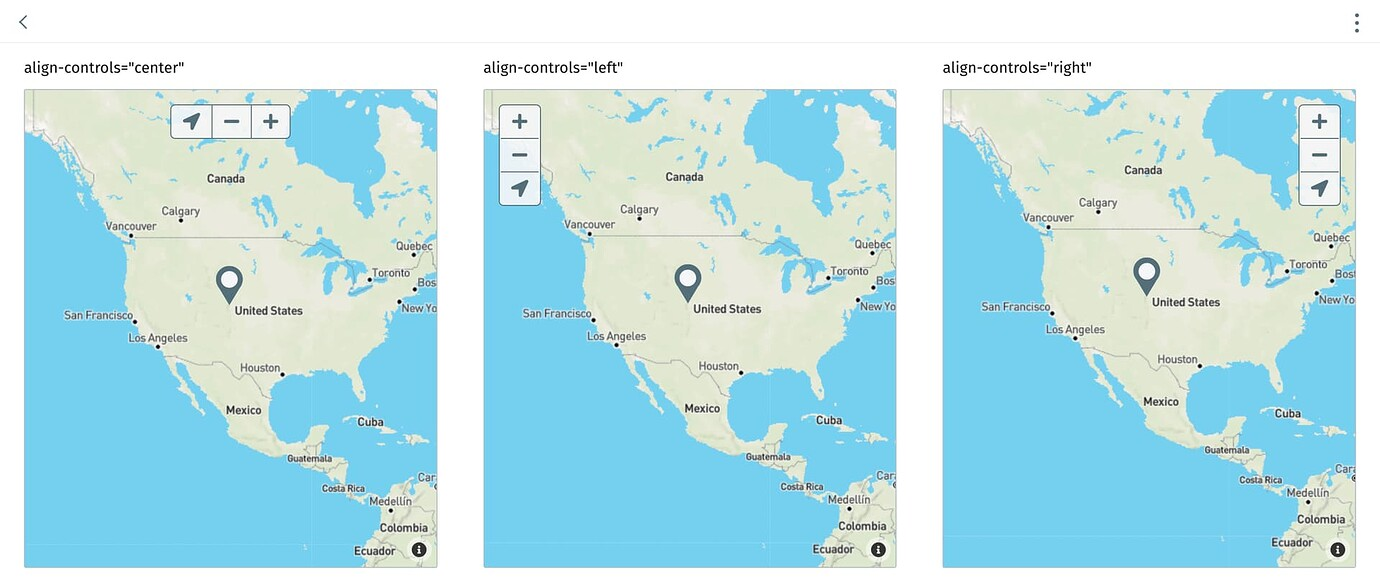
### `align-controls`
{% hint style="info" %}
**Version compatibility**
`align-controls` was introduced in version **4.86.1** of the JourneyApps Runtime.
{% endhint %}
**Optional**
**Type**: `center`|`left` | `right`
**Default**: `left`
Specify the alignment of the map’s controls. **Note**: controls are visible when the [`allow-zoom`](#allow-zoom) or [`allow-dragging`](#allow-dragging) attributes are enabled.
{% code title="main.view\.xml" %}
```xml
align-controls="center"align-controls="left"align-controls="right"
```
{% endcode %}
### `align-label`
{% content-ref url="../xml-fields/align-label" %}
[align-label](https://docs.journeyapps.com/reference/build/ui-components/xml-fields/align-label)
{% endcontent-ref %}
### `allow-dragging`
{% hint style="info" %}
**Version compatibility**
`allow-dragging` was introduced in version **4.82.0** of the JourneyApps Runtime.
{% endhint %}
**Optional**
**Type**: `boolean`
**Default**: `false`
Allow panning the map through touch gestures or mouse click-and-drag movements.
```xml
```
### `allow-zoom`
{% hint style="info" %}
**Version compatibility**
`allow-zoom` was introduced in version **4.82.0** of the JourneyApps Runtime.
{% endhint %}
**Optional**
**Type**: `boolean`
**Default**: `false`
Display the zoom controls on the component and allow changing the zoom level of the map with touch gestures or by scrolling.
{% tabs %}
{% tab title="capture-coordinates" %}
{% code title="main.view\.xml" %}
```xml
```
{% endcode %}
{% endtab %}
{% tab title="display-coordinates" %}
{% code title="main.view\.xml" %}
```xml
```
{% endcode %}
{% endtab %}
{% endtabs %}
### `height`
**Optional**
**Type**: `integer`
**Default**: `500`
Specify the height (in pixel) of the `capture-coordinates` / `display-coordinates` component.
{% tabs %}
{% tab title="capture-coordinates" %}
{% code title="main.view\.xml" %}
```xml
```
{% endcode %}
{% endtab %}
{% tab title="display-coordinates" %}
{% code title="main.view\.xml" %}
```xml
```
{% endcode %}
{% endtab %}
{% endtabs %}
### `label-case`
{% hint style="info" %}
**Version compatibility**
`label-case` was introduced in version **4.81.0** of the JourneyApps Runtime.
{% endhint %}
{% content-ref url="../xml-fields/label-case" %}
[label-case](https://docs.journeyapps.com/reference/build/ui-components/xml-fields/label-case)
{% endcontent-ref %}
### `label-color`
{% content-ref url="../xml-fields/label-color" %}
[label-color](https://docs.journeyapps.com/reference/build/ui-components/xml-fields/label-color)
{% endcontent-ref %}
### `id`
{% content-ref url="../xml-fields/id" %}
[id](https://docs.journeyapps.com/reference/build/ui-components/xml-fields/id)
{% endcontent-ref %}
### `on-change`
{% hint style="info" %}
**Version compatibility**
`on-change` was introduced in version **4.82.0** of the JourneyApps Runtime.
{% endhint %}
{% content-ref url="../xml-fields/on-change" %}
[on-change](https://docs.journeyapps.com/reference/build/ui-components/xml-fields/on-change)
{% endcontent-ref %}
### `on-location`
{% hint style="info" %}
**Version compatibility**
`on-location` was introduced in version **4.82.0** of the JourneyApps Runtime.
{% endhint %}
**Optional**
**Default**: unset
**Triggered when**: The user selects a location within the map
**Event parameter**: `$value`
**Return value**: Location object containing the latitude and longitude
`on-location` is an event that calls a JS/TS [`$:function`](https://docs.journeyapps.com/reference/app-features/calling-js-functions-from-xml) or [navigation](https://docs.journeyapps.com/reference/get-started/journeyapps-fundamentals/view-navigation). See more details:
{% content-ref url="../js-ts-events" %}
[js-ts-events](https://docs.journeyapps.com/reference/build/ui-components/js-ts-events)
{% endcontent-ref %}
{% code title="main.view\.xml" %}
```xml
/>
```
{% endcode %}
{% code title="main.js" %}
```javascript
function onLocation(location) {
console.log(location);
// Example:
// Object{latitude: 39.7553694, longitude: -105.0195773}
}
```
{% endcode %}
{% hint style="success" %}
Set `allow-zoom` and `allow-dragging` to `true` to allow users to navigate to different locations on the map.
{% endhint %}
### `show-if` and `hide-if`
{% content-ref url="../xml-fields/show-if" %}
[show-if](https://docs.journeyapps.com/reference/build/ui-components/xml-fields/show-if)
{% endcontent-ref %}
{% content-ref url="../xml-fields/hide-if" %}
[hide-if](https://docs.journeyapps.com/reference/build/ui-components/xml-fields/hide-if)
{% endcontent-ref %}
### `show-markers`
**Optional**
**Type**: `boolean`
**Default**: `true`
Show or hide all the markers on the map. `show-if`/`hide-if` on individual markers is also available.
{% tabs %}
{% tab title="capture-coordinates" %}
{% code title="main.view\.xml" %}
```xml
```
{% endcode %}
{% endtab %}
{% tab title="display-coordinates" %}
{% code title="main.view\.xml" %}
```xml
```
{% endcode %}
{% endtab %}
{% endtabs %}
## Component Methods
The following component methods are available when an [`id`](https://docs.journeyapps.com/reference/build/ui-components/xml-fields/id) is assigned to the component and `component.captureCoordinates({id:'my-id'})` / `component.displayCoordinates({id:'my-id'})` is called from JS/TS:
### `getMapState`
{% hint style="info" %}
**Version compatibility**
`getMapState` was introduced in version **4.82.0** of the JourneyApps Runtime.
{% endhint %}
Programmatically retrieve the current state of the map which will contain the current center and zoom position of the map.
{% tabs %}
{% tab title="capture-coordinates" %}
{% code title="main.view\.xml" %}
```xml
```
{% endcode %}
{% code title="main.js" %}
```javascript
try{
component.captureCoordinates({id: 'my-id'}).getMapState();
}catch (e) {
// handle exception here
}
```
{% endcode %}
{% endtab %}
{% tab title="display-coordinates" %}
{% code title="main.view\.xml" %}
```xml
```
{% endcode %}
{% code title="main.js" %}
```javascript
try{
component.displayCoordinates({id: 'my-id'}).getMapState();
}catch (e) {
// handle exception here
}
```
{% endcode %}
{% endtab %}
{% endtabs %}
### `setMapState`
{% hint style="info" %}
**Version compatibility**
`setMapState` was introduced in version **4.82.0** of the JourneyApps Runtime.
{% endhint %}
Programmatically set the center and/or zoom position of the map to a specific value.
{% tabs %}
{% tab title="capture-coordinates" %}
{% code title="main.view\.xml" %}
```xml
```
{% endcode %}
{% code title="main.js" %}
```javascript
try{
component.captureCoordinates({id: 'my-id'}).setMapState({
zoom: 12,
center: new Location({longitude: -33.00, latitude: -10.00})
});
}catch (e) {
// handle exception here
}
```
{% endcode %}
{% endtab %}
{% tab title="display-coordinates" %}
{% code title="main.view\.xml" %}
```xml
```
{% endcode %}
{% code title="main.js" %}
```javascript
try{
component.displayCoordinates({id: 'my-id'}).setMapState({
zoom: 12,
center: new Location({longitude: -33.00, latitude: -10.00})
});
}catch (e) {
// handle exception here
}
```
{% endcode %}
{% endtab %}
{% endtabs %}
### `scrollIntoView`
Programmatically scroll until the `capture-coordinates` component is visible in the view.